New map layer
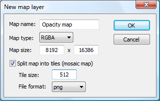
Each map project in L3DT usually has a number of map layers, such as the design map, heightfield, water map, etc. With custom scripts or plugins, you may also wish to add custom map layers (e.g., as a mask for a plugin calculation). The 'Layers→New map layer' menu option allows you to do just this. The control window is shown below:
Map name
L3DT stores and accesses maps based on a name, which you may set in the 'map name' text field. This name must have a non-zero length, and cannot match the name of an existing map layer. You may use spaces in the name, but you may not use the following characters:
- ' (apostrophe)
- ” (quotation mark)
- . (period)
- <
- >
The following map names are reserved by L3DT, and may not be used:
- DM
- HF
- WM
- AuxWM
- WS
- AM
- TN
- LM
- SH
- TX
- Design map
- Heightfield
- Water map
- Auxiliary water map
- Salinity map
- Attributes map
- Terrain normals
- Light map
- Shadow map
- Texture map
Map type
At present, L3DT allows the following custom map layers:
| BYTE | A simple 8-bit map. Typically used for masks. |
|---|---|
| WORD | A 16-bit map. May be used for two-component masks, or for representing heightfields as short integers. |
| RGB | A 24-bit colour map. Typically used for textures images, or for three-component mask maps (e.g. alpha maps). |
| RGBA | A 32-bit colour map. Typically used for four-component mask maps (e.g. alpha maps). |
| DWORD | A 32-bit map. Typically used for long index maps. |
| float | A 32-bit floating-point map. Typically used for heightfields or for high-precision masks. |
Map size
Using the map size text fields, you may enter the desired number of pixels in the map. The constrains on maximum map sizes are as follows:
| L3DT Standard | 2,049×2,049 pixels. |
|---|---|
| L3DT Professional | 8,193×8,193 pixels (non-mosaic), or 2,097,152×2,097,152 (mosaic). |
There are no constraints on aspect ratios.
Mosaic options
Split map into tiles
This check box determines whether the map will be tiled as a mosaic map, or will be stored as a single file. This option also determines the maximum allowable size of the map (see above), as tiling enables memory caching.
Tile size
The size-length, in pixels, of each individual tile in the mosaic map. 512 is default. Larger values may increase calculation speed, but also increase RAM usage.
File format
Mosaic maps are automatically saved/loaded from disk. Before this can happen, you must select the file format to be used from the file format drop-list. The list of file formats is determined by the chosen map type, and the file format plugins that are installed.
Other settings
You may be wondering why you cannot in this window set the horizontal scale, wrap flag, or other map settings that are available in the algorithm wizards (e.g. heightfield size, fractal parameters, etc.) The reason is that these settings are inherited from the project:
- The horizontal scale of every map in the project is automatically calculated from the size and horizontal scale of the heightfield, such that the extents of all maps are equal. All maps in a project cover the same area.
- If the heightfield has wrapping enabled, so to do all maps in the project.
Thus, you cannot independently set the horizontal scale of a map layer, or have a wrap flag for a map layer that is different from the rest of the maps in the project.
