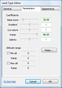
Some land types might be prevalent at one altitude but scarce elsewhere (eg. snow in a desert climate will only exist at higher altitudes). Thus in L3DT each land type has an altitude range, which is defined by the MinAlt and MaxAlt settings. These settings are accessed from the parameters tab of the land type editor dialog:

The Min alt number sets the minimum height for this land type, measured in metres. The ramp setting allows you to blur the cutoff edge, by gradually lowering the score of this land type. For example, a 'snow' land type might have a minimum altitude of 800m and a band width of 100m, which means the snow line will be found between 700 and 800m depending on the gradient/curvature/water/etc settings of the land type, with 'natural' blending.
The Max alt setting works in the same way as Min alt, except that it sets the maximum height for the land type.
The Min alt and Max alt settings are only used if their check-boxes are checked.

