|
Table of Contents
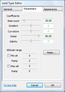
Land type parametersThe distribution of land types, as calculated by the land type assignment algorithm, is dependent on the value of several parameters and coefficients, listed below. These settings are accessed from the parameters tab of the land type editor dialog, as seen below. Base scoreThe base score value is the default 'score' of the land type in the land type assignment calculation. The various other coefficients add to or subtract from this score. The Base score is modified by the altitude range values, such that the land type has an effective base score of 0 outside the defined altitude bands. Typically the base score is set so that the maximum score of a land type is around 100. For example, a grass land type with a water coefficient of 20 (and 0 for other parameters) would be given a base score of 80, and so the 'high score' of this type would be 100. This is not a hard-and-fast rule, but merely a guideline for saving sanity. GradientThe gradient coefficient determines how the score of a land type changes with the gradient (or steepness) of the terrain. The gradient coefficient is usually high for cliffs (say ~100), zero for grass, and negative for land types that are not usually found on slopes, such as sand. CurvatureThe curvature coefficient determines how the score of the land type changes with curvature (or 'bumpiness'). Normally the curvature coefficient is set to zero, but on rocky rocky terrain types it may be positive, and on loose/sandy/snow land types it may be negative. WaterThe water coefficient determines how the score of the land type changes with the water-level in the water map. Typically values for some land types are:
You do not strictly need to use the water coefficient if you are only flooding the water map using a water plane. In such cases it may be easier to control the coverage of sandy land types using the altitude range settings. For an example of both approaches, please consult the climate tutorial.
Land types that have a high affinity only for salty water (eg. beach sand) will have a comparatively low water coefficient, which is compensated by a high salinity coefficient (see below).
SalinityThe salinity coefficient determines how the score of the land type changes with the salinity in the water map. For most land types, this will be zero. This can however be positive for land types that are only found near the sea (e.g. beach sand) and may be negative for land types that are only found away from the sea (e.g. lake mud). The effect of the salinity coefficient is to increase the water coefficient in areas where the water map has high salinity (see salinity map). The salinity coefficient has no effect if the water coefficient is zero. NotesA recommended method of setting the value of land type coefficients is provided in the making a new climate tutorial. Two things to note from that tutorial are that:
Except where otherwise noted, content on this wiki is licensed under the following license:CC Attribution-Share Alike 3.0 Unported
|

