|
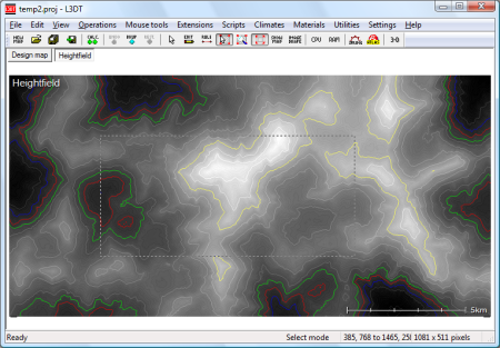
This is an old revision of the document! Cropping mapsTo crop the size of the currently displayed map layer, first enable the select area mouse tool, and left-click and drag to select the desired area (see below). Note that the status bar displays the start and end coordinates and the size of the selected area.
You do not need to be ultra-precise when using the section tool, as you will be able to modify the exact selection coordinates later.
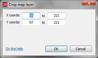
Once you've roughly selected the area you wish to keep, select the 'Layers→Crop' menu item. This will open the 'Crop map layer' window, shown below:
In this window, you may set the exact coordinates to be cropped. The initial values will be those of the area selected using the select area mouse tool. Once you click OK, L3DT will crop the map to the area selected.
L3DT uses a right-handed coordinate system. Consequently, the origin point for map coordinates (0,0) is at the bottom left-hand corner of the map display window.
Except where otherwise noted, content on this wiki is licensed under the following license:CC Attribution-Share Alike 3.0 Unported
|


