|
Table of Contents
Ten years of L3DTHi Everyone, L3DT version 1 was released ten years ago today, and it seemed to me like a good opportunity to take a stroll down memory lane to look at how the program has changed over the years, to reminisce about the more quaint aspects of the old user interfaces, and to chuckle at just how wildly inaccurate some of my development plans and projections were. However, before I get all misty eyed talking about long-since deleted dialog boxes and the like, I should first like to thank all the users who have contributed to the development over the years, either by reporting a bug, requesting a feature, purchasing a license, asking or answering a question in the forum, telling other people about L3DT, or by helping the project along in other ways. Thank you all, I couldn't have done it without your encouragement and support. Over the next week or so I'll post about each of the 14 major releases of L3DT to date, covering a couple of releases per post. I'll describe the significant changes, and cast a critical eye over what I got right, and not-so-right. Today's instalment covers the first year (and first four releases) of L3DT, in which the fundamentals of L3DT were established, including the heightfield and texture generators, and the whole processing pipeline.
Users of L3DT Professional can play along at home, as every one of the old releases of L3DT are still available for download from the 'archives' page on the L3DT Professional downloads site (see your reg/receipt e-mail for the link).
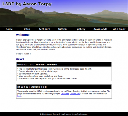
We begin, appropriately enough, with version 1: v1.0, July 2003The genesis of L3DT was, I think, a year or two before the first public release in July of 2003. The back story was that I'm a bit of a fan of real time strategy games like Total Annihilation, and thought I'd try my hand at making an RTS with really large 3D terrain maps. Something like Supreme Commander, only a few years beforehand. However, I fairly quickly found that the task was well beyond my skills and available time, so I focussed on a smaller part of the project: how to make large, realistic 3D terrain maps. By July 2003, I was (apparently) satisfied with what I had done thus far, and so proceeded to upload L3DT version 1 to my GeoCities website. Incidentally, that site was my very first experiment with HTML, and it showed (see below). Fortunately, I had a lot of help from my good pal Stuart Gooding, who is a web wizard.
L3DT release 1.0 had a remarkably basic user interface. Everything was menu-driven, and there were no manual editing tools, nor wizards, progress boxes, or any other mod-con that one might expect. This was one of my first Windows applications, and I clearly still had much to learn (and still do.) However, behind the crudely crafted dialog boxes of L3DT release 1 was a program architecture and work flow that would be familiar to L3DT users today. As with modern L3DT, maps were generated from a processing pipeline that started with a design map and ended with a texture map, via the heightfield, water map, attributes map, normals map, and light map. Some map names were different back then, but the contents and concepts continue through to today's version. Creating a new map in L3DT 1.0 was a simple affair, with only a few settings to choose:
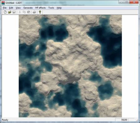
The default map size was 1280×1280 heightfield pixels, and the maximum size was 12800×12800 heightfield pixels. It was even possible to generate larger heightfields using a very early implementation of mosaic maps. Mosaic maps were supported when you used the 'large map' generator, which was sort of like an even larger-scale design map for the design map. If you made a 'large map', the maximum final heightfield size was theoretically 51200×51200 pixels. I doubt anyone ever tested this limit, given the appalling speed of the v1.0 heightfield generator, and the relatively poor processor speeds at the time. The heightfield generator in L3DT v1.0 was quite different to that in 'modern' L3DT; it simply added together thousands/millions of peaks to build up the height map, where the number and size of peaks in a region were determined by the design map. This was phenomenally slow. Worse still, it did not make very realistic terrain, since it didn't calculate erosion, cliffs or terraces, nor fractal noise. A typical heightfield, as shown in the 2D view, looked like this:
As with all other versions of L3DT, the colours in the texture were determined by the coverage of land types in the attributes map. However, in v1.0, solid colours were used for each land type, as texture images weren't supported until v2.1. Also, there were only four land types to be used (grass, sand, rock and snow), and they were all hard coded. The climate editor wouldn't arrive until v2.4. Typical texture output from L3DT v1.0 looked like:
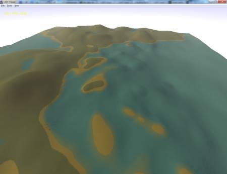
One of the more popular features of L3DT these days is the broad range of supported file formats. This was not so in L3DT v1.0. All maps were stored in custom binary file formats like HFF. Texture maps could not be loaded or saved as part of the project, but could be exported as 32-bit bitmaps. L3DT did come with a standalone 3D viewing application called 'L3DT Viewer', also written by Stuart Gooding, using Delphi and the GLScene library. It did a really good job of making my dull maps look interesting:
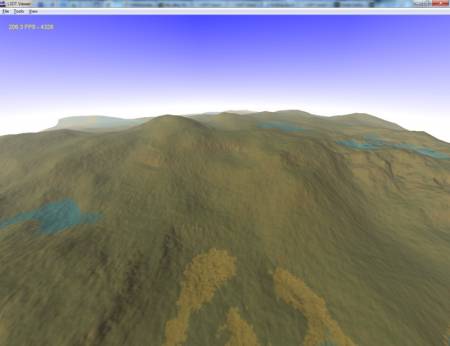
That's about it for v1.0. Version 1.5 would soon follow… v1.5, July 2003Version 1.5 was released five days after v1.0, but was a major improvement. This update was much faster at generating heightfields, thanks to the use of a new interpolation routine that generated the heightfield from the design map. This wasn't quite the same as the fractal inflation routine used today, but the concept was similar. This version of L3DT also introduced fractal noise, cliffs and terraces, and mountain overlays. The net result was much more realistic terrain than the previous version, although the textures were still a bit rubbish:
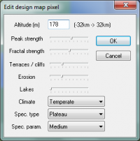
This version was the first to allow manual editing of the design map (then called the 'intermediate map'). However, editing was extremely laborious, using the edit design map pixel window to edit individual pixels one by one. Although editing the design map now uses a brush tool, the old pixel editing window is still used today (with minor modifications, see below), and is the oldest control window that is still in L3DT.
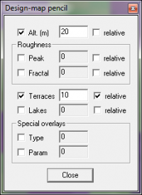
This version also added progress bars for calculations. However, these early progress boxes were pretty simple, and niceties such as cancel buttons and time estimates would have to wait for release 2.2a. Incidentally, the original progress boxes are still in use with the current release of L3DT when loading and saving map files. Otherwise, the user interface of v1.5 was pretty similar to v1.0. v2.0, August 2003L3DT version 2 again improved the heightfield generation speed, and introduced the 'fractal inflation' algorithm that is more or less the same as is still used today (but without the erosion, which has to wait until v2.2). This version also removed the 'large map' generator from v1.0, which had never been developed to a stage where it was actually useful. This also meant that mosaic map support was dropped, to re-appear in v2.1. Version 2 introduced the first brush-like tool window for editing maps; the 'design map pencil' (see below), which was later to become the design map brush still used today. This tool allowed users to paint changes onto the design map, albeit with a 1-pixel brush size.
Shadow casting and water absorption effects also debuted in v2.0, producing more realistic and pleasing light maps:
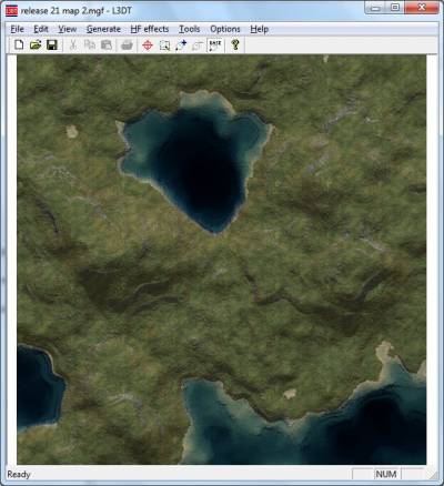
Finally, this version changed the layout of a number of the proprietary binary file formats, and generally broke backwards compatibility. Clearly, I still got some of the formats wrong, as they were changed again for v2.1 (which incidentally is largely compatible with the current release.) Looking back, L3DT 2.0 was still clearly a long way from being particularly useful for game development. It could produce what were, at the time, large heightfield maps relatively quickly, but it as very difficult to plan out and design a heightmap, which is kind of a deal-breaker. The texture generator was also still quite primitive, using only solid colours for the different land types. That would change in v2.1… v2.1, November 2003Version 2.1 was a major improvement in a number of areas, and was - dare I say it - at the cusp of being useful for game development. Firstly, the texture generator was upgraded to use texture images for each land type, rather than just solid colours. Furthermore, the texture generator would now produce 'high resolution' textures, with greater detail than the heightmap. The results were pretty respectable at the time:
Keen-eyed users may also notice that there were a few new buttons on the toolbar. Apparently by this release I had worked out how to use the resource editor in Visual Studio to change the toolbar, but judging by the number of greyed-out default buttons (cut, print, etc.), I still had more work to do. Nonetheless, progress is progress.
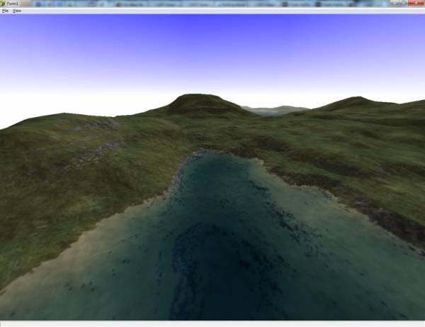
Version 2.1 re-introduced mosaic maps, which had been dropped in v2.0. This time around, they worked properly, and allowed maps to be generated that were too big to fit in RAM at once. The original size limit was 2 gigapixels (i.e. 32k × 32k). Mosaic maps were supported for the heightfield and all derived map types, including the texture map. Since big maps were now possible, the map display in L3DT 2.1 also now included the ability to zoom. L3DT 2.1 still didn't have a climate editor or support for multiple climates, but the climate was now loaded from a file (standard.cli) rather than hard-coded, so it could be edited using a text editor if you were determined. Useful file format options were added to L3DT for the first time with v2.1, including import and export to TerraGen's TER file format, the Virtual Terrain Project's BT file format, and bitmap images. The heightfield and water map file formats (HFF and WMF) were also updated, resulting in the file formats still used by L3DT. Due to all the other changes in L3DT's file formats, Stuart Gooding released an all-new 3D viewer, entitled L3DTVi2. It was nice, and would continue to be used until Sapphire was introduced with L3DT v2.5.
Stay tunedIn the next instalment of 'Ten years of L3DT', we'll cover L3DT release 2.2 and 2.3 (2004-2005), in which L3DT got threads, wizards, optimisations, an installer, alpha maps, a new website, and much much more. Stay tuned… Except where otherwise noted, content on this wiki is licensed under the following license:CC Attribution-Share Alike 3.0 Unported
|

