Heightfield does not match exported mesh.
Hi,
Here is a picture in blender of the exported mesh and a picture of the exported heightfield together:
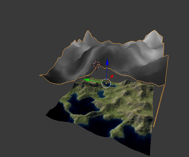
As you can see, they are completely incorrect. If I bring them down on each other, there appears to be hills where there weren't hills previously, and everything, although it somewhat seems to look like the terrain, doesn't appear to be in the right place.
I have tried:
[*]Rotating the terrain by 90, 180, and 270 degrees.
[*]Flipping the terrain & Negative scaling.
[*]Changing the scale of the terrain.
[*]Changing the tile it's on top of (It doesn't just not fit with the tile, it doesn't fit with any tile).
If necessary, I can just use a heightmap for my entire terrain instead of a model, however I would much prefer a model due to looking better graphically, and I need a matching heightmap for efficient collision detection.
Thank you again
Joe
Here is a picture in blender of the exported mesh and a picture of the exported heightfield together:
As you can see, they are completely incorrect. If I bring them down on each other, there appears to be hills where there weren't hills previously, and everything, although it somewhat seems to look like the terrain, doesn't appear to be in the right place.
I have tried:
[*]Rotating the terrain by 90, 180, and 270 degrees.
[*]Flipping the terrain & Negative scaling.
[*]Changing the scale of the terrain.
[*]Changing the tile it's on top of (It doesn't just not fit with the tile, it doesn't fit with any tile).
If necessary, I can just use a heightmap for my entire terrain instead of a model, however I would much prefer a model due to looking better graphically, and I need a matching heightmap for efficient collision detection.
Thank you again
Joe