Page 1 of 1

Sapphire errors when rendering hf2

PostPosted: Fri Dec 14, 2007 1:16 pm
by monks
Version: Pro 2.5b build 8

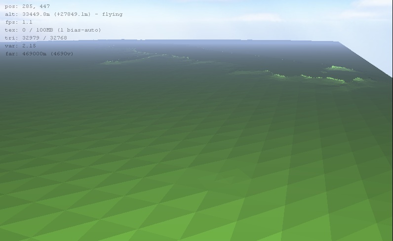
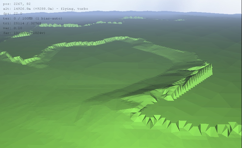
Hi Aaron, I'm getting some pretty strange renderings in Sapphire. I originally exported the file from GM. Imported into L3DT, rendered. I then also tried exporting that file from L3DT and reimporting into L3DT. Same errors.

Image

monks

PostPosted: Mon Dec 17, 2007 10:54 am
by Aaron
Hi Monks,

I can't quite tell from the screencap, but this may be the same as the tile frustrum culling bug. If so, the 'fix' (and I use the term loosely) is to disable the 'Options->Frustrum culling' option in Sapphire.

Can you tell me the dimensions of your map (in pixels) and the horizontal scale of your map (metres, or whatever distance metric you please)? Also, does the heightmap look as expected in the 2D view in L3DT?

Cheerio,
Aaron.

PostPosted: Tue Dec 18, 2007 5:23 pm
by monks
mmm, I posted a reply to this the other day- doesn't seem to be here.

The frustrum fix doesn't solve it. The map appears ok in 2D view.
5643 @ 100m scale.

The terrain renders like a flat plane but suspended in the air: the axes are mixed up.

monks

PostPosted: Wed Dec 19, 2007 9:47 pm
by Aaron
Hi Monks,

Can you please zip the HF2 file and send it to me for testing (aaron.torpy@yahoo.com). I can't quite see what's going wrong from your screenshot.

Best regards,
Aaron.

PostPosted: Sat Dec 22, 2007 8:45 am
by Aaron
Hi Monks,

Thanks for the file. The problem is that the y=0 rows of pixels are set to -99999m, whereas the rest of the map is at ~5600 metres or above. What is the original source of the file? If you can't fix it there, you can fix it in L3DT by using the copy and paste feature to copy a 1-pixel thick row of pixels from y=1 to y=0.

As for the rendering in Sapphire; the camera starts at a few hundred metres above the (x,y)=(0,0) corner of the map, which for this map will be way down in the hundred kilometre deep trench at y=0. Thus, all you'll see initially will be the big wall going up to the 'normal' terrain at y>0. Moving the camera one step forwards would have pulled you up out of the trench, and shown you something like this:

Image

I notice the map is very flat. Here's the normals map:

Image

The only readily visible features are those ridges, which look a bit weird to me:

Image

Was this what you were expecting?

Cheerio,
Aaron.

PostPosted: Mon Dec 24, 2007 6:56 am
by mauronen
It seems Misty Mountains (with a bit spiky profile :wink: ).

PostPosted: Mon Dec 31, 2007 4:57 pm
by monks
Hi Aaron, yes, it looks like you've identified the problem. It all looks as it should be. The dataset in GM doesn't fit the area exactly- so it's probably filling in null height values or something. That can be rectified within GM easily enough.

monks

PostPosted: Tue Jan 01, 2008 8:09 pm
by monks
More on this- I've imported a ter from GM into L3DT. Bringing up the change vert scale dialog, it gives min = 0, max = 9958, and % above sea level = 99%.

That smells fishy to me. % above sea level should be 100%. When you mouse over the heightfield there is nowhere on the map anywhere near to o alt- though when I zooked right in in Wilbur I could spot a 1 pixel border at 0 alt. I think there is a collar (on at least one side) set to 0 alt. I think this is a problem with GM export, when cropping the dem to a vector selection. No doubt this is what happened with the hf2 as well.

monks

PostPosted: Tue Jan 01, 2008 8:48 pm
by monks
It just so happens that someone had a similar problem with kml export with GM- a fix was uploaded. GM was giving priority to sample spacing over export bounds. There's now an option to prioritise bounds. So hf2 fixed too!

monks