Page 1 of 2
My hot requests. Part 1. :)

Posted:
Tue Feb 13, 2007 12:23 pmby Leon PRO
1. Color buttons for quick changing (viewing) maps "DM", "HF", "WM", ..., "TM" on toolbar (or custom toolbar "Maps" with buttons). If some maps not calculated - button is gray.
2. Button "Run this map in L3DTVi2" on toolbar, or menu. If some required maps not calculated - button is gray.
Posted:
Wed Feb 14, 2007 12:43 pmby Leon PRO
3. Option "Show grid in DM" - showing gray grid (DM pixel separator) in DM.
4. DM brush "Blure DM pixels" with custom blure strength.
5.

HotKey "
Invert current operation". Example: If you paint +100 altitude brush, and make error - simply press "Alt", and your "Altitude" brush parameter changed to "-100". Touch error DM pixel, and revert altitude back, then release "Alt"! Easy!

6. Preview HF in L3DTVi2 (or in something else) without calculating Attribute map, Texture map,... etc. Simply, for look form of landscape in 3D.
Posted:
Fri Feb 16, 2007 10:51 amby Aaron
Hi Leon,
1. Color buttons for quick changing (viewing) maps "DM", "HF", "WM", ..., "TM" on toolbar (or custom toolbar "Maps" with buttons).
I'll think about it. There are the 1/2/3/etc keys right now.
2. Button "Run this map in L3DTVi2" on toolbar, or menu. If some required maps not calculated - button is gray.
I'll do this for the rendering plugin. L3DTVi2 is very nearly deceased.
3. Option "Show grid in DM" - showing gray grid (DM pixel separator) in DM.
Done for next release.
4. DM brush "Blure DM pixels" with custom blure strength.
Added to-do list.
5. HotKey "Invert current operation".
Interesting. Added to to-do list.
6. Preview HF in L3DTVi2 (or in something else) without calculating Attribute map, Texture map,... etc.
Already done in plugin. Needs more debugging before release, though.
Thanks for the suggestions!
Aaron.
Posted:
Mon Feb 19, 2007 2:08 pmby Leon PRO
Thanks for replies!
next part...
7. Field "Seed" on Perlin and Fractal generation algorithms. (And optional checker "Random Seed"). Need, because I can`t "tune" noise for generating HF. Every little changs on parameters - give totally new HF =(( (Now, I think, every process of generation map give new seed into program)
Posted:
Mon Feb 19, 2007 3:00 pmby Aaron
Hi Leon,
Thanks for the suggestion. It's on the to do list now as well.
Cheers,
Aaron.
Posted:
Mon Feb 19, 2007 3:28 pmby Leon PRO
8. IMHO, need replace dialog "Discard changed Y/N" to "Save changes Y/N". Because it inverse for most actual programms and, sometimes hands pressing not actual button =((.
Posted:
Fri Feb 23, 2007 1:03 amby Aaron
Hi Leon,
Leon PRO wrote:8. IMHO, need replace dialog "Discard changed Y/N" to "Save changes Y/N". Because it inverse for most actual programms and, sometimes hands pressing not actual button =((.
No problems. I've done this for the next release.
Cheers,
Aaron.
PS: If you don't mind me asking, what qualifies a program to be an "actual program"?
Some New
Posted:
Thu Jul 12, 2007 9:18 amby Leon PRO
Button "Cancel" for terminate process of exporting HF to files.
Posted:
Thu Jul 12, 2007 11:41 amby Aaron
Hi Leon,
Okay, it's on the to-do list. I suspect this will require a partial re-write of all format plugins, so it might take a while.
Cheers,
Aaron.
Posted:
Fri Aug 31, 2007 10:53 amby Leon PRO
Hallo again ))))
Very need info about current HF min/max point (in meters). With choosen precision in options of HF maps preferences.
Now i do this for get info:
Export -> .mmf
Open and get data from .mmf file.
So slow =(
Posted:
Fri Aug 31, 2007 11:03 amby Aaron
Hi Leon,
I suggest you use the 'Operations->Heightfield->Set vert. scale' option (
see here). In that dialog box, you can find the min/max altitude values in the edit boxes beneath the histogram.
Best regards,
Aaron.
Posted:
Mon Sep 03, 2007 3:47 pmby Leon PRO
Good day!
Yes, I know about this method, but I need more precision, 6+ digits after point (.mmf file contain 6 digits - that is enough for Me)
Posted:
Sat Sep 08, 2007 5:39 amby Aaron
Hi Leon,
Okay, I'll put it on the to-do list.
Cheers,
Aaron.
Posted:
Tue Oct 09, 2007 10:18 amby Leon PRO
Thanks!

Some new.
On double click on some maps (i think - HF) - see properties windows of some pixel data like:
Gradient coeff.
Curvature coeff.
This is will good information for high precision and more quicken climate building.
Posted:
Tue Oct 09, 2007 10:52 amby Aaron
Hi Leon,
Would this be OK?
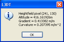
(these are the values and units that are used for the AM calculation)
If so, consider it included in the next release.
Cheers,
Aaron.