atGeoRef2
Plugin information
| Author | Aaron |
|---|---|
| Description | This plugin allows users to edit the georeferencing settings for L3DT's project. |
| Menu option | 'Settings→Georeferencing' (in L3DT v2.6 and later). |
| Download link | Included with L3DT installer. |
| Last update | v2.7.2.0, released 18th of April 2008. |
Using atGeoRef2
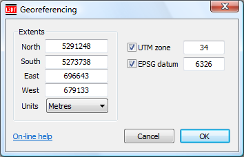
To edit the georeferencing settings of the L3DT project, select the 'Settings→Georeferencing' menu item in L3DT. This will open the 'georeferencing' window, shown below:
Extents
The extents fields give the coordinates of the north/south/east/west edges of the project.
- If the units selection box is set to 'degrees', these extents represent the latitude/longitude of the project edges.
- If using the 'metres', 'feet (int.)' or 'feet (U.S.)' units and the UTM zone checkbox is enabled, the extents represent the offsets from the origin of the UTM zone.
UTM zone
The UTM zone number identifies the Universal Transverse Mercator zone (1-60), if the file is in UTM. Negative zone numbers are used for the southern hemisphere.
EPSG datum
The EPSG datum number identifies the survey data reference point system. Valid EPSG Geodetic Datum Code, which are in the range of 6001 to 6904. If you do not care about datum, the default value is 6326, which is the WGS84 Datum.
Where are the settings stored?
The georeferencing settings will be stored in the project's map definition file (*.def.xml). Additionally, if the heightfield is stored in the BT or HFZ/HF2/HF2.GZ file formats, the georeferencing data will be stored in the relevant header sections of those files.
More information
The georeferencing system in L3DT is based on the georeferencing system used in the binary terrain file format developed by the Virtual Terrain Project (VTP).
Changes
2009/04/18 — Released v2.7.2.0, with support for EPSG projection code.
2008/06/08 — Released.
