Page 1 of 2
Problem importing a terragen heightfield

Posted:
Sun Aug 13, 2006 8:37 pmby dennis
I'm trying to create a terrain using USGS NED data. After downloading the TIF image I load it into 3DEM and save it as a Terragen terrain. This terrain is 2049 x 2049 in size and opens fine in Terragen. Unfortunately the terrain doesn't import correctly. Imagine an overhead view of the terrain, cut it in half and then stack the two parts on top of each other so that you can see both in the same window. Any ideas why this would happen?
Update - Problems importing heightfiled
Posted:
Sun Aug 13, 2006 9:00 pmby dennis
After running the various maps and importing to the viewer the terrain has generated fine. Aparently this is a problem with how the map is displayed in L3DT?
Posted:
Mon Aug 14, 2006 3:02 amby Aaron
Hi Dennis,
Thanks for the bug-report. Could you please post a screenshot, or e-mail one to
aaron.torpy@yahoo.com? Better-still, could you e-mail me the TER file in question?
Cheers,
Aaron.
Posted:
Sat Aug 19, 2006 3:22 pmby dennis
Yes, I'll send a screen shot and the terr file to you by email.
Posted:
Mon Aug 21, 2006 2:08 amby Aaron
Hi Dennis,
Thanks for the file. Can you explain what steps you take to get this error? It loads OK when I open the file by 'file->import->heightfield' or by 'file->open'. Also, which version are you using? (check with 'help->about L3DT'.)
Best regards,
Aaron.
Posted:
Tue Aug 22, 2006 1:54 amby dennis
I'm using Release no: 2.4 Rev. 19, Build date: 20-July-06. I used the same process as you: file -> Import -> Heightfield.
Posted:
Wed Aug 23, 2006 7:18 amby Aaron
Hi Dennis,
Gosh, I'm very sorry for this fault. I've not been able to reproduce it with the latest version, but I'll revert to 2.4.0.19 later tonight and see how I go. Perhaps you could try the latest updater? We're now on version 2.4a build 2.
Thinking some more about this; you're right, this is most likely a display issue and should not effect the actual data. I was planning on doing a re-write of the 2D renderer in a few months time, but I may bring that forward if the problem persists.
Has anyone else in the forums found a problem like this?
Best regards,
Aaron.
Posted:
Wed Aug 23, 2006 1:03 pmby Aaron
Hi Dennis,
Just a follow up; I can load the file OK in v2.4 build 19, so I guess this is a PC-specific bug (possibly a multi-threading bug, which can vary depending on processor speed). I'll try to reproduce it on some other boxen.
What CPU do you have, by the way?
Regards,
Aaron.
Posted:
Wed Aug 23, 2006 2:38 pmby dennis
I am using an Athlon XP 3200+ with the nForce2 chipset (EpoX EP-8RDA3+PRO board). Graphics card is an Asus GeForce 6800. No overclocking.
Posted:
Wed Aug 23, 2006 3:20 pmby Aaron
Thanks Dennis,
That's a wee bit faster than my ageing dev box (XP2600), so I know where to start looking now. I'll give it a go on something rather quick at work tomorrow.
Cheers,
Aaron.
Posted:
Fri Aug 25, 2006 2:31 amby dennis
I downloaded the latest version and tried the same thing on a 1.7 ghz pentium IV Dell GX240 with the same results. Using the new version on the AMD also produced the same problem.
By the way, thank you for your support on this. I really appreciate it.
Posted:
Fri Aug 25, 2006 2:55 amby dennis
Here are some images that show the problem that I'm having. L3DT is generating a terrain, I just can't view it in the 2D viewer.
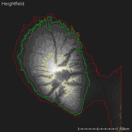
1. I'm trying to model a part of the island of Maui, the part in the black square in this image:

[/img]
2. Unfortunately the 2D view folds the image.

3. In the end the terrain is completed and can be viewed in the viewer.

For now I am just learning how to get a terrain like this generated and imported into TSE Atlas2. Later I will need to be able to edit the terrains so it would be helpful to see it properly. Has anyone seen this and if so were you able to get past it somehow?
Posted:
Fri Aug 25, 2006 8:32 amby Aaron
Hi Dennis,
This is what I get on my AMD XP2600 and on an Intel 3.2Ghz P4 from work:
Do you find that L3DT is messing-up the rendering of the other maps too (eg. texture map), or is it just the heightfield?
Is it any different when when you do 'View->Redraw map' or 'View->Show map->Heightfield'?
Regards,
Aaron.
Posted:
Sat Aug 26, 2006 8:14 pmby dennis
no, it doesn't change the way the map is displayed. I also tried upgrading the video driver with no improvement.
Posted:
Mon Aug 28, 2006 2:40 amby Aaron
Hi Dennis,
I might be getting a bit closer on this one, but I have a few more questions:
1) If you generate the water map, does it render correctly? It should look
like this.
2) Does the salinity map render OK? (use 'view->show map->salinity map'). It should look
like this.
3) With the heightfield, does it make any difference to enable/disable the contour lines? (view->display effects->show contour lines).
With any luck, the answers to these questions should allow me to zero-in on the bug.
Best regards,
Aaron.