Table of Contents
Heightfield:Generator:Fractal filter
Filter info
| Description | Generate a heightfield using fractal subdivision. |
|---|---|
| Author | Aaron |
| Plugin | ZG_fractal |
Looks like
Input pins
This filter has no input pins.
Output pins
| Name | Type | Description |
|---|---|---|
| hMap | hvar | A handle to the fractal heightfield created by this filter. |
Options
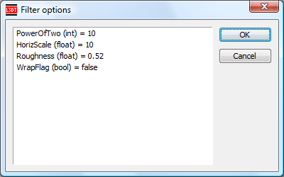
The filter options window for the Fractal filter looks like:
The options are as follows:
| Option name | Data type | Description |
|---|---|---|
| PowerOfTwo | int | The desired size of the heightfield, expressed as a power of two. See table in comments for equivalent sizes in pixels. |
| HorizScale | float | The desired horizontal spacing between map pixels, in metres. |
| Roughness | float | The noise octave amplitude propagation coefficient. A value of ~0.5 is typical. Larger values give rougher terrain. |
| WrapFlag | bool | A flag for whether the map's north/south and east/west borders should tile seamlessly with one another. |
To edit any of the values, double left-click the mouse on them.
Comments
Size and PowerOfTwo
| PowerOfTwo | Map size in pixels |
|---|---|
| 0 | 1×1 |
| 1 | 2×2 |
| 2 | 4×4 |
| 3 | 8×8 |
| 4 | 16×16 |
| 5 | 32×32 |
| 6 | 64×64 |
| 7 | 128×128 |
| 8 | 256×256 |
| 9 | 512×512 |
| 10 | 1024×1024 |
| 11 | 2048×2048 |
| 12 | 4096×4096 |

