|
Table of Contents
Importing a heightfieldHeightfields can be imported into L3DT using the 'File→Import→Heightfield…' option in the menu. Supported formatsAt the time of writing1), L3DT supports the following import formats:
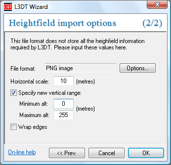
Links to further format info may be found here. Importing from imagesWhen importing from image files you will be asked to input some values, including the altitude range and the horizontal scale: If you are importing a RAW image, you also need to set some import options using the 'Options…' button (discussed next). Importing from RAW filesBecause raw binary data files contain, in general, no useful header information, you must specify additional information when importing a RAW, including the width and height, mode (i.e. data type), and header size (if any). These settings may be reached by clicking on the 'Options…' button in the above wizard. 1)
March 2009
Except where otherwise noted, content on this wiki is licensed under the following license:CC Attribution-Share Alike 3.0 Unported
|

