|
Table of Contents
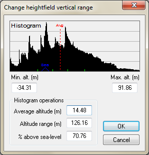
Changing the vertical rangeYou may find that after generating your heightfield that it's too steep or flat, should be moved up or down, or perhaps the sea coverage should be changed. The change heightfield vertical range window (below) allows you to do all this, and is accessed from the 'Operations→Heightfield→Change vertical range' option in the menu. The controls are as follows: Min. Alt. and Max. Alt.The height, in metres, of the lowest and highest point in the heightfield. Changing these values will shift and re-scale all values in the heightfield to fit between these values.
To invert the heightfield, switch the minimum and maximum altitudes (ie. make min > max).
Average altitudeThe average height of all points in the heightfield, in metres. Changing this value will shift all the terrain up or down, without changing the altitude range. Hence, the steepness will be unaffected. Altitude rangeThe difference between the maximum altitude (max. alt.) and the minimum altitude (min. alt.) within the heightfield, in metres. Changing this value will leave the average altitude unaffected, but will increase or decrease the distance between the minimum and maximum values. A smaller range value will produce flatter terrain, whilst a larger range value will produce steeper terrain. % above sea-levelThe percentage of area in the heightfield that is above sea-level (defined to be 0 metres). Changing this value will shift all values up or down, without changing the altitude range. Except where otherwise noted, content on this wiki is licensed under the following license:CC Attribution-Share Alike 3.0 Unported
|

