L3DT users' community
Large 3D terrain generator

Earthdawn Atlas

Any and all chit-chat regarding L3DT.

Earthdawn Atlas

Postby Telarus » Wed Jun 03, 2009 2:22 am

Hey everyone. Just got the Pro trial and am poking around with it. So far it is 'teh awesome', as they say. 8)

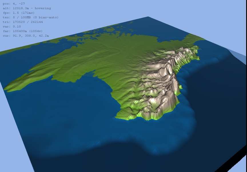
The project I'm working on is similar is scope to the ME-DEMs project. I'm attempting to map the locations in the Earthdawn game-world (originally a FASA game, now produced by RedBrick in NZ, and printed by Mongoose publishing).

The original Earthdawn maps made it pretty clear that it was loosely based around real-world terrain. Later books and tie-ins with the ShadowRun gameworld made the connections to Earthdawn as Shadowrun's pre-hostory much more explicit.

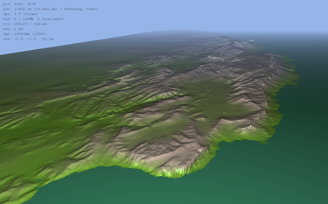
Here's a downsampled pic of the area I will be working with:
Image

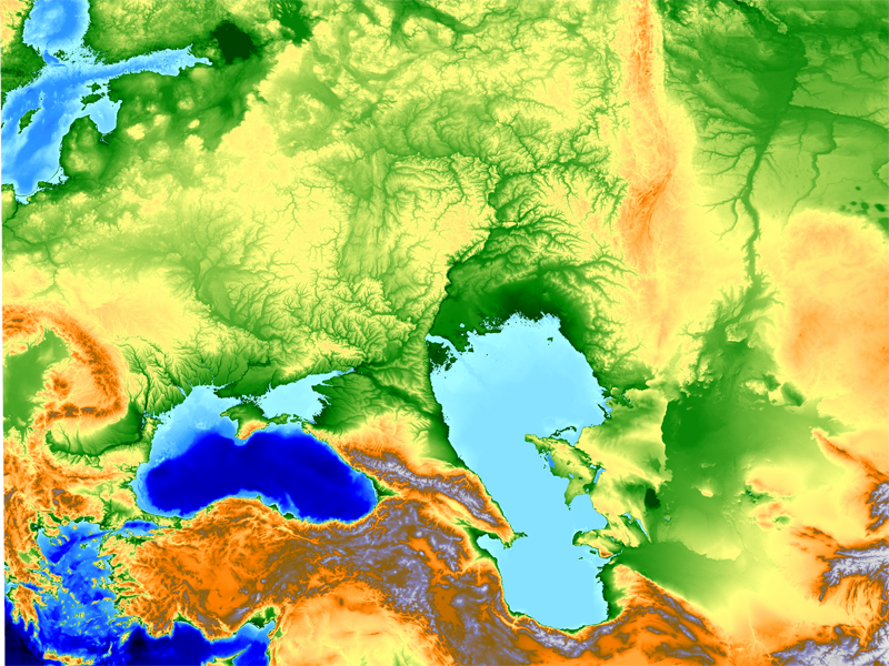
As you can see, it's HUGE (4096Km by 3072Km).

The key points of interest are the Volga River system (known as the Serpent River and the focal point of much of the in-game politics), the island of Santorini in the Greek Isles (known as Thera and capitol of the major enemy Empire), and the Caspian and Black Seas (the northern Black sea and the sea of Azov, just north of the Black Sea, are flooded with molten Lava in the gameworld).

Additionally there are major changes to the terrain to be added, such as whole mountain ranges near the Volga/Serpent, the aforementioned lava sea, as well as interesting climate differences such as isolated tropical jungles.
-----------------------------------------------------------------------

Ok, first question: Does anyone have any tips for working with such a large landmass?

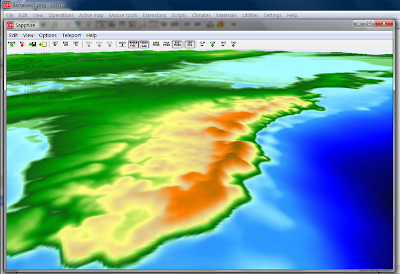
I'm currently trying to import a GeoTIFF @ 1km scale into L3DT, starting with a (blank)designable map project. First thing I noticed was an error when importing the heightfield.

Code: Select all
CL3DTio_TIFF::LoadMapFile warning:
 - unsupported GTModelType


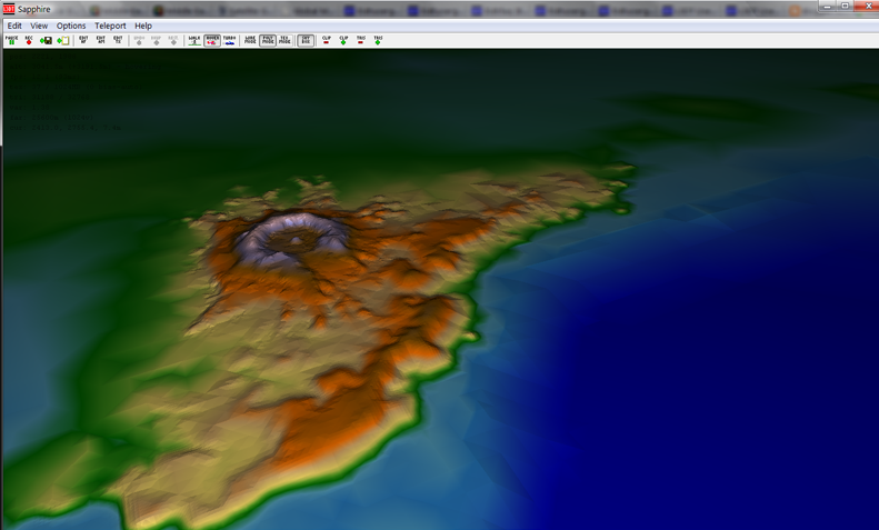
And that in Sapphire, the vertical scale is _waaaaay_ off, with vertical walls and spikes going up far past the view distance.

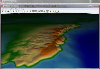
When I checked Operations>Heightfield>Change Horiz. scale, I noticed that it had it as "1.000" instead of "1000". So, I changed that, and it seemed to normalize the spikes, etc.

I then also changed the vertical scale to the range I got from the metadata from the GeoTIFF.

That just made it worse than before I changed any of the scale settings.

My friend who is providing me with the elevation data thro Global Mapper has noticed that GM can export hf2(hfz) files. Would that be a better base to start from?
Last edited by Telarus on Wed Jun 03, 2009 11:19 pm, edited 1 time in total.
Telarus
Doyen
 
Posts: 112
Joined: Mon Jun 01, 2009 12:34 am

Postby Aaron » Wed Jun 03, 2009 11:08 am

Hi Telarus,

The GeoTIFF support in L3DT is still developmental, which means it doesn't fully support all the different tags that may be used within a GeoTIFF file. Clearly, in this case, it didn't support the tag that GlobalMapper used to encode either the extents or the step size, and thus it got the horizontal scale wrong (it defaults to 1m/vertex).

If you can, please send me (aaron@bundysoft.com) a small region of your map as a GeoTIFF so that I can correct the GeoTIFF plugin to support your map files*. The more GeoTIFF files I get from different sources, the better L3DT's GeoTIFF support will be.

As for using HFZ, I say go for it. L3DT fully supports all of the the defined HFZ tags.

Best regards,
Aaron.

* If you can keep the file under 1MB, that'd be grand. I don't need much map area to fix the GeoTIFF tags.
User avatar
Aaron
Site Admin
 
Posts: 3696
Joined: Sun Nov 20, 2005 2:41 pm
Location: Melbourne, Australia

Postby Telarus » Wed Jun 03, 2009 11:59 pm

Awesome. Working with HFZ files seems a bit faster.

I've sent you a section of the GeoTIFF I was working with, hope that helps with that error.
------------------------

Onward!

As the elevation values for a map this large kinda get lost unless false colored, I've decided to play around with scale a little.

The plan is to reset the scale from 1Km down to 200m once I have it in L3DT. This should (as I'm not changing the pixel resolution, or the min-max elevation) give the landscape the appearance of being 5 times as high as actual scale. (I may even go to 100m scale, we'll see).

I'm going to do this for 2 reasons:

-The full large-scale map will be presented to GMs and Players as an overview of the Province. At that point, readability and symbolic representation come ahead of accuracy.

-This should make it easier to work with the Climate and Texture-splatting in L3DT. I tried running all the Calc maps from my heightfield, but I got only snow, grass and sand. This is probably because at the 1Km scale, the angles between pixels never get steep enough to get assigned as cliffs/etc/etc. This should also make editing in the mountain ranges that i need to a little easier.

I have also clipped off anything below -1500m to -1500m, just to simplify things.

I'll try to get some in-progress screenshots up once I see if this technique will work.
Telarus
Doyen
 
Posts: 112
Joined: Mon Jun 01, 2009 12:34 am

Postby Aaron » Thu Jun 04, 2009 1:02 pm

Hi Telarus,

Thanks very muchly for the GeoTIFF file. I've fixed up the GeoTIFF plugin to support different vertical units (int'l feet, in your map), and projected model types. This means the plugin now gets the vertical and horizontal scale right when loading the file.

However, I don't have full support for all the geo-referencing tags in your file just yet. Specifically, I have it loading the UTM zone OK (based on the Projection CS code), but I'm haven't yet calculated the extents from he model tiepoint. I'll leave this as an exercise for the weekend...

Anyway, the updated GeoTIFF plugin will be included in the next developmental build of L3DT. Thanks again for the help!

Cheerio,
Aaron.

PS: A little screenshot, with the horiz scale reduced to 100m/vertex to exaggerate the vertical relief:

Image
Last edited by Aaron on Thu Jun 04, 2009 2:37 pm, edited 1 time in total.
User avatar
Aaron
Site Admin
 
Posts: 3696
Joined: Sun Nov 20, 2005 2:41 pm
Location: Melbourne, Australia

Postby Aaron » Thu Jun 04, 2009 2:33 pm

Hi Telarus,

By the way, did you know about the 90m resolution SRTM GeoTIFFs you can get from the CGIAR-CSI website? These are pretty big data files, but they do offer quite reasonable detail.

For example, the same southwest corner of Crimea rendered from the SRTM survey (without vertical exaggeration):

Image

SRTM doesn't contain the nice bathymetry data of the sea floor, however, so if you want to use this data you may want to do some sort of masked combine operation with the two datasets.

Cheerio,
Aaron.
User avatar
Aaron
Site Admin
 
Posts: 3696
Joined: Sun Nov 20, 2005 2:41 pm
Location: Melbourne, Australia

Postby Telarus » Thu Jun 04, 2009 6:17 pm

Wow, I was not aware of the 90m SRTMs, thanks!


Hmmm, that gives me something to think about as that level of detail would be much better for my purposes. Would probably have to mosaic it all up and work on clusters of tiles.

Thanks again. I'll let you know if I run into any more little bugs or anything.
Telarus
Doyen
 
Posts: 112
Joined: Mon Jun 01, 2009 12:34 am

Postby Telarus » Fri Jun 05, 2009 12:36 am

Ok, still playing around with the tools and learning the editing.

Also, I hacked my own 128 pixel tall height-scale into the Sapphire resources. Here are 2 pics, the first with the imported texture-map from the hi-rez origonal (no polygon lighting), the second with the my custom height-based scale (polygon lighting by default as it it dynamically generated).
Image Image


Can I stretch that image larger and have the full resolution show up in the 3d engine, or are those values hard-coded?

Also, the Point Grab tool doesn't seem to be working for me.

I click and hold and push up/down and then a little calc window flashed, but the terrain isn't changed. No errors that I can see in the log, tho.


Here's a volcano that I sketched out using my wacom tablet and the /raise /lower /avalanche /noise and /smooth tools:

Image
Telarus
Doyen
 
Posts: 112
Joined: Mon Jun 01, 2009 12:34 am

Postby Aaron » Tue Jun 09, 2009 10:13 pm

Hi Telarus,

Looking good!

Telarus wrote:Can I stretch that image larger and have the full resolution show up in the 3d engine, or are those values hard-coded?


The size of the elevation texture is not hard-coded, so you can change the size to whatever you like. The mid-point is assumed to be sea-level.

Telarus wrote:Also, the Point Grab tool doesn't seem to be working for me.


Thanks for the bug report. I've fixed this for the next dev build, which should be available in the next day or so.

Best regards,
Aaron.
User avatar
Aaron
Site Admin
 
Posts: 3696
Joined: Sun Nov 20, 2005 2:41 pm
Location: Melbourne, Australia


Return to General discussion

Who is online

Users browsing this forum: No registered users and 28 guests

cron