monks
| L3DT users' community |
|
| Large 3D terrain generator |
What heightfield tools do you require?
33 posts
• Page 2 of 3 • 1, 2, 3
Arron would you happen have a suggestion on how to paint a road in L3DT using the mosaic texture images to use with a feature like above?
From the mad cows desk to yours,
Peace Madcowthomas Yo...Reggie vacation mom! "Without imagination we would cease to exist" William Thomas (1970-) Warning! Burping Babies are the Cause of Global Warming!
aaron, i advise you to try out the BF2 editor terrain editor (if you have bf2) as its terrain edtior is kinda limmited, but the features it dose have is nice.
some things off the top of my head i would like to see
thats all i can think of right now anyways
Thinking be nice to have markers that you can insert information , like the height that need in certain areas, or just like a post note. Even like a waypoint, like a beam light that marks a spots where want town or anything.
From the mad cows desk to yours,
Peace Madcowthomas Yo...Reggie vacation mom! "Without imagination we would cease to exist" William Thomas (1970-) Warning! Burping Babies are the Cause of Global Warming!
Hi guys,
Just to put my 2 cents in. I asked last year if you would set it up so we could have smaller brushes that would allow us some finer detail and you had it on your to-do list. Was wondering what happened to it. This post reminded me that you were going to work on that one and this post looks like you could very easy add that feature into this one and make it very awesome. Besides roads, and setting up town sites it would also be nice to go in and be able to cut the painting brush down to at least a 1/8 of the size say a 10m map would be. That way nice little details could be made to the map. I am still waiting for that feature /smiles..... A good example is, when I make a 32m map I have a ton of boxes to create in, I would like to be able to have the same amount of boxes in a 10m instead of the 10-20 or so we have now. OK that all make sence? It is early and I need coffee to wake up, but I really would like to have this feature in L3DT with this post, side by side kinda. Can you do that Boss? I sure would be a happy Camper /smiles. DT Quantum Psychics is the future of man!
ATOMIX Productions http://atomixgroup.com http://theatomizer.com http://atomixworldmarket.com http://indiemusicsociety.org http://texturesource.org
Hi Everyone,
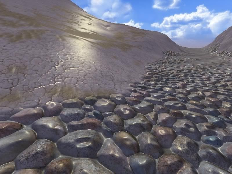
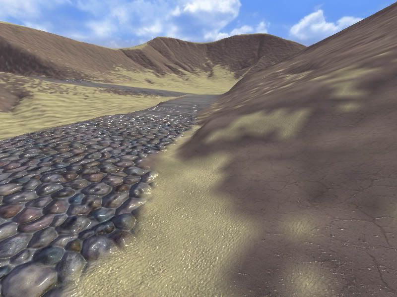
Thanks again for the feedback. I've added a roughen tool to the dev plan. The smoothing tool was already there, but I'll add raise-only and lower-only options. I've also put user-defined markers/tags on the to-do list. Regarding grids on the terrain: I'll have to think a bit more about the right way to overlay lines on the terrain, given the high likelihood of z-buffer fighting issues (the terrain is a highly irregular triangle soup following the optimisation). Regarding brush ring radius: I have this going in wireframe mode, but haven't adapted it yet for the polygon/textured modes because of the z-fighting issue. Once I figure it out, I'll do both this feature and the grid-lines feature together. Oh, concerning how to paint roads on the texture: I suggest you use the attributes map brush in L3DT to paint the roadway onto the attributes map. You'll want to make a high-res AM for this, and also probably overlay either the normals map or the light map over the attributes map using the image drape feature to help with working out where the road edges are. Here is a quick-n-nasty example, using the 'pebbles' land type as my roadway: 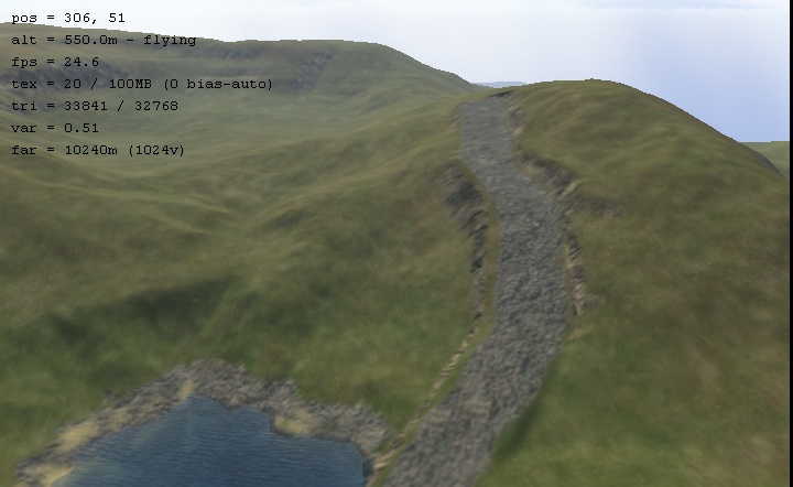
You'll probably want to make a custom 'road' land type to hold your road textures. All the parameters of this land type other than the texture settings can be left empty. I'm still thinkering on the right way to automatically overlay the road texture. I think I may need to add another mask map to the project for custom overlays like roads, building footprints, etc. Anyway, thinking in progress... Finally, regarding DeathTwister's question about the different sizes of the design map brush. I think I mentioned quite some time ago that to have a higher-resolution design map (such as is required to do what you want) will require a new heightfield algorithm. It's not just a matter of changing a brush. This is still on the to-do list, but at the moment I'm dealing with other priorities (better heightfield editing, undo, etc).I will get back to this at some point, but I can't say when right now. Cheers, Aaron.
Thanks Arron for that information on making roads.
From the mad cows desk to yours,
Peace Madcowthomas Yo...Reggie vacation mom! "Without imagination we would cease to exist" William Thomas (1970-) Warning! Burping Babies are the Cause of Global Warming!
New user here. I bought the Pro, and it's got my quad cores running at about 50% consumption generating 15sq miles of desert terrain!
I'm still learning more about the app, beyond the walk-through. If there's two features that I would like to have, though #1 more than #2: 1. Pressure-sensitive tablet support. I purched Bryce because I think it's got some fantastic landscaping features, but the heighmap editor is horrible. I don't like the suggestion I received to paint my map in a separate app then import it -- that defeats the purpose. When I came across L3DT I thought the idea was so novel and right on target for terrain generation and mappings that it fit perfectly with Bryce -- I can generate then import and work on other things. Tablet support is a really nice feature to have when altering maps. 2. Support for 3DConnexion devices, like SpaceNavigator, for moving around 3D environments. Not necessary, but a perk --
Ah, I love the smell of fresh QuadCore in the morning!
Nice work Aaron
How about Alpha brush support for drawing landscapes, ala Zbrush?.
Hey Aaron,
Awesome news I couldn't find it on the dev plan though :S But than again, i am running on 3hrs. sleep at the moment, so it could be that..lol
Please, Please, Please DO THIS!! This concept occured to me the other day. I was thinking along the lines of writing my own attribute map editing tool and adding those things to that map (outside of L3DT or using some of the plugin API stuff to do it within L3DT depending on how powerful that stuff is). I was actually going to go through the trouble of modifying torque to import that attribute map and automatically adjust the geometry accordingly. An extra overlay makes even more sense to import into atlas though (especially if L3DT modifies geometry based on it). Things like foliage locations, rocks, tree density, etc could be outlined on such a map. You could import the map at load time and populate the world with enviromental objects based on that map. Since we are on the subject of requests; I have huge one. Will it ever be possible to sort of generate all of the maps in a sort of Level of Detail generation style? What I mean is that I'd love to generate a 2Kx2K heightmap that represented my entire world and use the design tool to scope out different parts of it. Then come back and possibly "up" the resolution, perhaps detailing certian sections a bit more. Then maybe do it agian, etc. The issue I have is that L3DT creates great maps for only one specific scope it seems. If I want distance terrian it produces beautiful terrain from a distance but if you walk up to it's unresolute. I can get TGEA to import hieghtmaps that have a ton of resolution in them but it requires that I drop the size to 1m. The world features seem to be miniture at that res. Its seems like l3dt was designed for vast sweeping landscape. Not small localised feature scapes (though it seems to have some features for this type of scape as well). I have trouble getting it to do both well at the same time. Perhaps I am not thinking big enough though. Maybe I should be producing 8Kx8K (or bigger) heightmaps if I am doing things in a world design stage. But honestly 8K is hard to work in and take a long time to render (thus my LOD request Ves
Hi Vesuvias,
That's the general idea. My L3DT/Spring plugin already creates a feature map, and uses it to place texture overlays and 'metal patches'. I'll probably do much the same thing, but in a more generalised sense, for a feature map in L3DT. The challenging part is designing it in such a way that users/developers can easily add/modify the overlay effects. I have to do a bit more thinkering there.
Yes, probably in L3DT 2.6, with the proviso that when you 'up the resolution', you do it across the whole map. Having multi-resolution maps (i.e. different regions at different res) is not yet on the dev plan, in part because it's rather difficult, and in part because I can't think of a 'target' application that supports multi-resolution map import.
Yes, it was originally intended to generate terrain for RTS, much of the algorithm design and testing was done with sizes like 8k x 8k pixels at 10m/pixel. That said, I think you can still get nice FPS-style terrain close-up, but you do need to use high-res heightfields (e.g. ~1m). I think the only other substitute for pixel density (i.e. high-res terrain) is to use procedural geometry displacements in your 3D engine, but that seems to be the harder option.
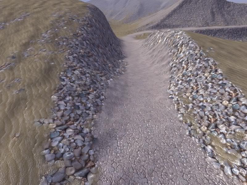
Have you tried increasing the 'scale of features' slider in the design map wizard? The other thing of course is that texture resolution greatly affects the prettiness close-up, and for an FPS I would say that 4x would be the minimum (16x for prettiness). If that's too much data, then runtime texture blending is the alternative. Hopefully to prove that I'm not just all talk, here's a screenie from walking around on a 1k x 1k heightfield (1m res, large feature scale) with 8k x 8k texture in Sapphire: 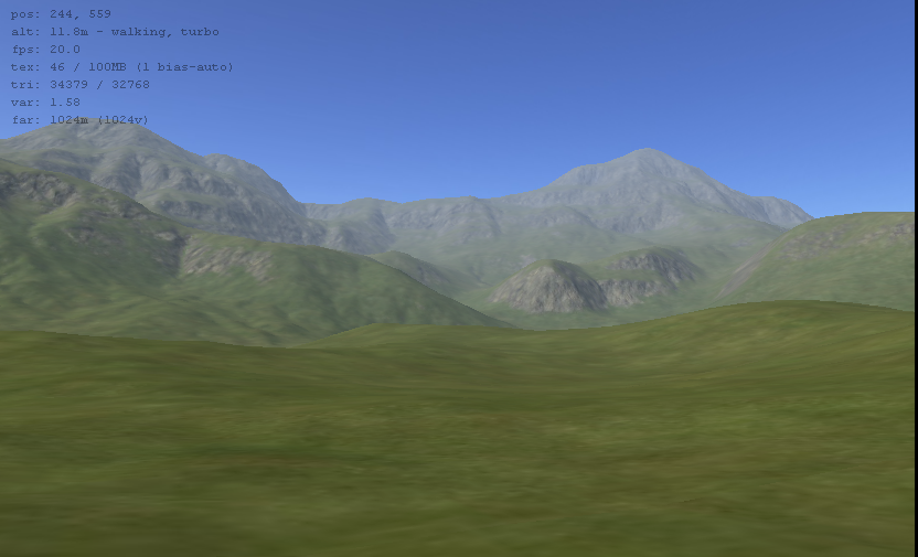
..and, moving ahead to the rock outcropping in the image above: 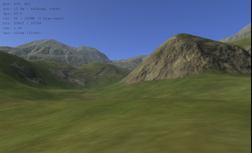
Is this FPS grade? Not as-is, but if you slap on some runtime effects like a detail map, a bumpmap/parallax shader, some foliage, a bit of bloom, and some loonies shooting at you, etc, I think it may not be too far off. The actual terrain in commercial FPS games is not all that spectacular when you strip away all the runtime decoration. It's probably also worth noting that Sapphire was written for the OpenGL 1.2 spec, which is rather antiquated, and it doesn't use a single shader. This is so that it can run on a wide variety of hardware, and for example, the screenies above are from an nVidia FX5700 with 128Mb of memory. A proper game engine like Torque/Ogre/etc should do much better. Cheerio, Aaron.
Think XML
I only mentioned multires in order to break up the design process a little better. Allowing one to work on one section of the map at a time (less resource itensive), that way I could design and compile features in l3dt without having to run the algorythim on the whole map. But honestly as long as you keep mosaics in then I should be able to create another project with scope the size of single mosiac tile and test changes there. The only use I could see to varying res's outside of L3DT would be if I wanted to show distance terrain but never actually wanted a user to travel there. think of it as outlying geometry that performs the same function as a skycube. I would have to change the engine anyway for such a feature or it would proably be easier to just use multiple maps for that.
My investigation of that very thing is what led me to this request. As I started to look at what random funciton or smoothing operation I was going to peform in order to turn one vertex into 25 (ie going from 10m res to 2m) I started to long for the algorythm you use to generate the terrain. I then thought how cool it would be if I took the design map variables for a particular chunk of terrain into consideration when I did the tessilation. If an area is more eroded its going to show signs of that in upclose geometry as well as the at-a-distance geometry. To get real accurate I would have to take the AM into consideration as well. I hate having to recreate L3DT on the small scale just to use it on the large scale. I sounds like 2.6 maybe solve this problem though if it allow us to up the resolution.
Yeah I just started playing with that, that in combination with playing with the meter scale is providing me with options I didn't know about before (I was always ouputing 1 or 2m scale since I needed that for torque not to look so blocky (the atlas importer is difficult to tweak). Nice shots, thats what I am looking for upclose for sure (1 to 2m is what I am targeting for res). Just to be clear I am not complaining about what comes out of L3DT when we have 1-2m res. This product rules creates great terrain that torque can import and use just fine (if you import it into the torque right, which is TGEA difficulty not yours). I started playing with blended terrains and getting torque to use bumpmapping for them. And the results have been very good I think : http://i5.photobucket.com/albums/y153/vesuvias/blended_speccast.jpg http://i5.photobucket.com/albums/y153/vesuvias/desertshot_blended.jpg http://i5.photobucket.com/albums/y153/vesuvias/Parralex-issues.jpg L3DT can create maps great Ves
33 posts
• Page 2 of 3 • 1, 2, 3
Who is onlineUsers browsing this forum: No registered users and 10 guests |


