Got a problem or need advice?
 by Martinloki » Sun Dec 23, 2007 11:10 am by Martinloki » Sun Dec 23, 2007 11:10 am
I searched the forms and RTFM, but I may not have used the right terms, so sorry if this is a repeat or covered somewhere else.
I am using a 96x96 DM and have a few long, diagonal coastlines. Once the DM is calculated I end up with jagged coasts that clearly follow the outlines of the DM squares. The coast squares are 15m and the squares next to them are 0m. Can't think of why that would matter, but just in case...
- Code: Select all
Getting:                         Want:
_                                   \
  |_                                  \
     |_                                 \
        |_                                \
           |_                               \
Is there a way to get the smooth coasts I want using the DM and the automatic calculation of the HF?
If not I can fix it with saphire or photoshop at the HF level, but that means I can not simply recalc if I want to make a change on a large portion of the map.
Thank you for any help or suggestions.
-
Martinloki
- Member
-
- Posts: 15
- Joined: Sat Mar 24, 2007 12:11 am
by Aaron » Wed Dec 26, 2007 10:07 am
Hi Martinloki,
This is one of the many artefacts inherent in the the Design/Inflate algorithm. Normally it is concealed by the other overlay effects such as erosion, noise, cliffs, etc, but if the strength of the overlays are set to low, then the stepping of the coastline can be particularly noticeable. I'll have a look into it to see whether I can fix this.
Cheerio,
Aaron.
-

Aaron
- Site Admin
-
- Posts: 3696
- Joined: Sun Nov 20, 2005 2:41 pm
- Location: Melbourne, Australia
-
by Leon PRO » Fri Jan 11, 2008 1:41 pm
For fix it i use "Chess DMP interpolation" ( ©Me  )
I think You will know what I mean for picture below:
http://picasaweb.google.ru/Leon.3D.Art/WebShared/photo#5154212389811614322 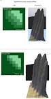
First picture - "Linear DMP interpolation", next - Chess.
Compare result )
Many many moths ago i ask about "blur" feature for DM brush - it really good thing for make any interpolations! -= I am from Russia, sorry for bad English =-
-

Leon PRO
- Luminary
-
- Posts: 58
- Joined: Fri Nov 10, 2006 6:41 am
- Location: Moscow, Russia
by Martinloki » Sun Jan 13, 2008 7:29 am
Thank you Leo.
I do like your results, but I am unclear how you got them. Did you manually correct the edges, or are you using a plugin?
Aaron, would folding in his solution be a possibility? Maybe as an option when generating the HM if not as a brush.
-
Martinloki
- Member
-
- Posts: 15
- Joined: Sat Mar 24, 2007 12:11 am
by Leon PRO » Mon Jan 14, 2008 11:07 am
Manually
-= I am from Russia, sorry for bad English =-
-
Leon PRO
- Luminary
-
- Posts: 58
- Joined: Fri Nov 10, 2006 6:41 am
- Location: Moscow, Russia
by Aaron » Wed Jan 16, 2008 7:58 am
Hi All,
Thanks Leon for that tip. I'll add a menu option to apply a 1-pixel radius blur filter to the design map altitude layer (this should achieve the same effect as manual editing).
Cheerio,
Aaron.
-
Aaron
- Site Admin
-
- Posts: 3696
- Joined: Sun Nov 20, 2005 2:41 pm
- Location: Melbourne, Australia
-
by Leon PRO » Wed Jan 16, 2008 12:11 pm
I'll add a menu option to apply a 1-pixel radius blur filter to the design map altitude layer
But why You don`t want make blur option (example checkbox) for brushes ? Much times it need for "bluring" pixel attributes, as Erosion, Terraces and other, or all in one time. -= I am from Russia, sorry for bad English =-
-
Leon PRO
- Luminary
-
- Posts: 58
- Joined: Fri Nov 10, 2006 6:41 am
- Location: Moscow, Russia
by Leon PRO » Fri Jan 25, 2008 9:06 am
Aaron, Can You say anything about previous question ?
-= I am from Russia, sorry for bad English =-
-
Leon PRO
- Luminary
-
- Posts: 58
- Joined: Fri Nov 10, 2006 6:41 am
- Location: Moscow, Russia
by Aaron » Sat Jan 26, 2008 11:05 am
Hi Leon,
Okay, I've added a blurring brush to the to-do list as well.
Cheerio,
Aaron.
-
Aaron
- Site Admin
-
- Posts: 3696
- Joined: Sun Nov 20, 2005 2:41 pm
- Location: Melbourne, Australia
-
Return to Help and support
Who is online
Users browsing this forum: No registered users and 25 guests
|