Any and all chit-chat regarding L3DT.
 by Aaron » Sun Apr 15, 2007 11:32 pm by Aaron » Sun Apr 15, 2007 11:32 pm
Hi All,
The latest version of the Sapphire 3D renderer (included with L3DT Pro 2.5 RC5, on the downloads page) has a raise/lower brush tool for sculpting terrain. I'm planning on adding a few more tool options, such as: - A smoothing tool.
- A levelling tool.
- A roughening tool.
- An erosion tool.
My question is, what other tools would you like to have?
Cheers,
Aaron.
-

Aaron
- Site Admin
-
- Posts: 3696
- Joined: Sun Nov 20, 2005 2:41 pm
- Location: Melbourne, Australia
-
by doooogle » Sun Apr 15, 2007 11:52 pm
*feels like a kid in a toyshop...*
Can't wait to play with the planned options... let me fire up the imagination and try to build a wish-list...
That said, i reckon your plan covers pretty much everything you'd want to do with a heightfield.
If you were talking about some of the other terrain aspects - climate, water, texture, blah blah blah - and making it truly editable from within the renderer... man, I think I'd wet myself... Oh well, I guess I can dream...  ... when in doubt ... have a beer ...
-

doooogle
- New member
-
- Posts: 7
- Joined: Wed Mar 07, 2007 1:14 am
- Location: Melbourne
-
by monks » Mon Apr 16, 2007 3:34 pm
 I was in Sapphire last night and had to look up the docs and saw wha...? Brush editing!
monks
-
monks
- Oracle
-
- Posts: 292
- Joined: Tue Nov 22, 2005 10:38 pm
- Location: Middle Earth
-
by geoadel » Tue Apr 17, 2007 4:13 pm
Hi Aaron,
as soon as you have the nice river-system implemented, I would really love to paint rough river-layouts with bezier-curves from source (highest point) to the end (lowest point). That would really help me out, because sometimes I have some broad ideas, where a river should flow along, but I would not want to create it all by hand editing the height of the design-map (which also would have to be of a quite high-resolution).
That might also be achieved by a brush, that would set the height to a certain amount and would gradually lower the painted hight which each painted cell, so that I could make a stroke over the landscape and have a downgoing path without lowering the height for each pixel by hand again and again.
I hope I am talking in a way that is comprehensible. But since English isn't my mothertongue please ask if there is something not easily understood.
Thanks for all the wonderful work
geoadel
-
geoadel
- New member
-
- Posts: 3
- Joined: Wed Apr 26, 2006 3:26 pm
by monks » Wed Apr 18, 2007 11:32 am
As geoadel said, rivers with beziers.  I'd also like those to double up for use as contours. The sheer sizes that L3DT is capable of + contours would be pretty powerful.
The problem with contours is that you might need an interpolation algo and a bezier with z height- but you'd need that for the rivers anyway wouldn't you?
I would suggest some kind of shp file support but it tends not to go down too well as it's kinda niche and 'unproven' in these parts
monks
-
monks
- Oracle
-
- Posts: 292
- Joined: Tue Nov 22, 2005 10:38 pm
- Location: Middle Earth
-
by Madcowthomas » Wed Apr 18, 2007 4:36 pm
A dig tool to allow your cut through the terrain craving streams and rivers. Something you set how deep it dig into the terrain or use a variable it adjusts from as you dig.
From the mad cows desk to yours,
Peace
Madcowthomas
Yo...Reggie vacation mom!
"Without imagination we would cease to exist"
William Thomas
(1970-)
Warning!
Burping Babies are the Cause of Global Warming!
-

Madcowthomas
- Doyen
-
- Posts: 159
- Joined: Mon Feb 19, 2007 3:40 am
- Location: Seattle Washington - Salmon Fishing
-
by Codey » Sun Apr 22, 2007 7:58 am
monks wrote:As geoadel said, rivers with beziers. I'd also like those to double up for use as contours. The sheer sizes that L3DT is capable of + contours would be pretty powerful. The problem with contours is that you might need an interpolation algo and a bezier with z height- but you'd need that for the rivers anyway wouldn't you? I would suggest some kind of shp file support but it tends not to go down too well as it's kinda niche and 'unproven' in these parts monks
Apart from the basic editing tools mentioned, this is probably the most important one in my opinion to create geographic features, rivers as mentioned, but also roads and paths too!.
You would need parameters for width, depth absolute/relative etc etc and it would be awesome!
If you could also apply texturing in the same way based on either the same besier or another one with texture specific parameters such as follow besier/world/tile xy etc
btw great work on L3DT so far!
-
Codey
- Newbie
-
- Posts: 1
- Joined: Sun Apr 22, 2007 7:50 am
- Location: Australia
-
by monks » Sun May 13, 2007 7:32 pm
I've just been using the heightfield editing tools and it seems you already have the beginnings of a river tool here. If you use the Lower tool first and then set the thermal ersoion to runlength='8' and go over the area- it seems like you get a pretty good gradient out of it.
Also, I've had what look like waterfalls- I think they would certainly pass for them if shaded well enough.

I think a threshold control over the lower and raise tools would be very useful as well.
monks
-
monks
- Oracle
-
- Posts: 292
- Joined: Tue Nov 22, 2005 10:38 pm
- Location: Middle Earth
-
by Morgan » Mon May 14, 2007 10:11 pm
This reminds me of the BF2 editor kinda
I'd like to maby see something you can make caves or sth with
-
Morgan
- Member
-
- Posts: 13
- Joined: Fri Feb 16, 2007 10:52 pm
by Q-dad » Mon May 28, 2007 3:15 pm
Hi, Aaron
1. Would it be possible to add flying/walking paths to the viewing mode of a terrain rendered in Sapphire, and then a start a batch job which would record frames from the path to a movie file (.wmv, .mov, etc.)...? (I see that you have a Flight-sim mode on the to-do list, but I'm not sure exactly what that would include). This could be a simple feature at the beginning, and one could add more control over the settings later, like for instance camera direction, speed, resolution, etc...
2. Would it be possible to add seamless tiling to Sapphire, and to be able to set how many times it should tile in each direction...? The flying/walking path feature suggested above would need to be able to cross the borders between seamless tiles of the terrain...
3. Regarding the to-do list (Export mesh from Sapphire as 3ds/obj.), would it be possible to export only parts of the complete mesh, i.e. by using the mouse to select 4 (or more) points in the horizontal plane, and then have this column (from zero and up) exported...?
-

Q-dad
- Luminary
-
- Posts: 97
- Joined: Tue Nov 22, 2005 11:54 pm
- Location: Jessheim, Norway
by Morgan » Mon May 28, 2007 10:47 pm
Two things i'd like:
brush enlargement
smoothing tool
nuf said...
-
Morgan
- Member
-
- Posts: 13
- Joined: Fri Feb 16, 2007 10:52 pm
by Lekane » Tue May 29, 2007 5:37 pm
A better flymode here  I'd love space bar to go up and Ctrl to go down for example
edit: ok nevermind, found it 
-
Lekane
- New member
-
- Posts: 8
- Joined: Tue May 29, 2007 4:49 pm
by Aaron » Wed Jun 06, 2007 1:01 am
Hello,
Thanks all for the suggestions. I've put most of them on the Sapphire to do list. My immediate goals for Sapphire (at the time of writing) are to improve the performance of mosaic texture rendering, then add a brush tool for painting the attributes map, such as to allow the painting of road surfaces in 3D. After that I'll look into more complex stuff like vector/spline-based tools for roads/rivers/etc.
Morgan wrote:brush enlargement
Have you tried the mouse scroll wheel? Or were you meaning something else?
Cheers,
Aaron
-
Aaron
- Site Admin
-
- Posts: 3696
- Joined: Sun Nov 20, 2005 2:41 pm
- Location: Melbourne, Australia
-
by Morgan » Wed Jun 06, 2007 2:20 am
aaron wrote:Hello, Thanks all for the suggestions. I've put most of them on the Sapphire to do list. My immediate goals for Sapphire (at the time of writing) are to improve the performance of mosaic texture rendering, then add a brush tool for painting the attributes map, such as to allow the painting of road surfaces in 3D. After that I'll look into more complex stuff like vector/spline-based tools for roads/rivers/etc. Morgan wrote:brush enlargement
Have you tried the mouse scroll wheel? Or were you meaning something else? Cheers, Aaron
Oh, never noticed that.
I'd love a spline/road/w/e tool
-
Morgan
- Member
-
- Posts: 13
- Joined: Fri Feb 16, 2007 10:52 pm
by Aaron » Sun Jul 01, 2007 5:39 pm
Hi All,
Here's the new bulldozer tool at work:
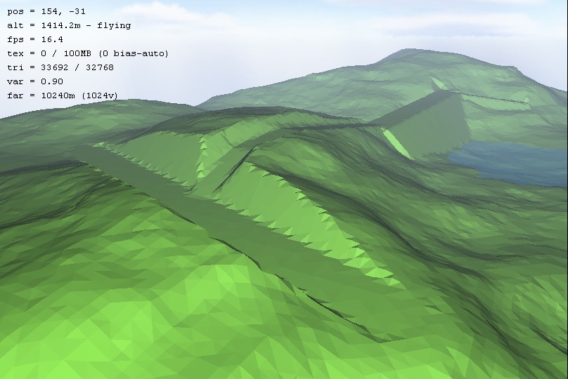
It's in the latest dev build (Pro 2.5.1.12, 1st of July).
Cheers,
Aaron.
-
Aaron
- Site Admin
-
- Posts: 3696
- Joined: Sun Nov 20, 2005 2:41 pm
- Location: Melbourne, Australia
-
Return to General discussion
Who is online
Users browsing this forum: No registered users and 47 guests
|
