This worked perfectly!!! I had an edge where I had inadvertenly wrecked the edges (outer boundary), and was having trouble getting the edges back to normal, and wasn't getting satisfactory results with GM (jagged areas where the old/new met), even with the feathering technique that is possible. And my efforts at manually correctly this were causing me to pull out my hair.
I will definitely be experimenting more, and seeing what kind of damage I can do!!!!
Thanks a million for this, and for the other work you put in (editing attribute maps). These techniques and improvements are going to be huge in my workflow.
Allan
| L3DT users' community |
|
| Large 3D terrain generator |
best of both worlds.. Imported HF but Cool terrain?
21 posts
• Page 2 of 2 • 1, 2
Re: best of both worlds.. Imported HF but Cool terrain?
Allan Luomala
SkyChasm Consulting - Military Simulation Terrain Specialist http://skychasm-consulting.ca/
Re: best of both worlds.. Imported HF but Cool terrain?
Sweet addition. I also pull DEM info through GlobalMapper, so I'll have to start experimenting. I was going to do overlay stuff in Mudbox, as that supports multiple layers of greyscale displacements each with it's own intensity/scale (like Zbrush). I also use MudBbox to render a lower res version of the heightfield and then create a normal map of the difference between the lower/higher res versions.
It seems like you can theoretically do this now in L3DT with some interesting ZGraph setup. I'll have to think of how to set that up. It would involve exporting the DM as a mesh or displacement map. Then re-sizing the DM to the same pixel height/width as the heightfield (probably as a new map-tab in L3DT), then running this filter to subtract the upsized DM from the eroded/detailed HM (not sure just a simple subrtaction would leave you with all the detail you want). Then a world-space normal calculation in L3DT. Then in your engine/renderer you import the lower res DM (mesh or displacement), and then the high res normal map would be applied onto that.
Re: best of both worlds.. Imported HF but Cool terrain?
I had a bit of a brainstorm today: it involved using this blendmap to create overlays to add terrain features. However, I ended up crashing L3DT, so I will go through the process I went through.
I had initially thought I could use overlays, as per this tutorial, but I soon realized that this can only be done with the Design Map (DM), and since I wanted to use this on real-world terrain, it wasn't doable (or am I wrong??). Anyway, I created an oval shape in GlobalMapper (GM) to simulate a hill (one could use contours in GM, but I decided to keep it somewhat simple at first). I exported a frame for my whole area (black, to be set to 0m elevation in L3DT) and then exported my oval shape as a white feature. I then combined both, exported as a PNG, brought this into L3DT as a heighfield and set the horiz resolution to match my real-world heightfield (4096x4096) and set the maximum height to be 10m. My reasoning for this: due to the crappy terrain data that I used (basically SRTM), my terrain is quite smooth (even though it is in a mountainous area), but I don't want to add unrealistic terrain features, so I determined that 10m maximum would keep things realistic. I modified the BlendHeightfield graph script to have all of the different possibilities (add, substract, max, min, multiply), and saved each with its own name. I am taking a guess here, and I may be completely wrong, but it is this: if I use BlendHeightfield map (with the add modifier), in conjunction with my original terrain, use the HF that I created from my GM export, and then either used a completely white mask (i.e allow the whole terrain to be modified, albeit 99% will have an "add 0m" to it, with my oval shape (max height 10m) being added to only that one area) or the very same mask that I used to create the heightfield (black, with a white oval (which would allow the exact same sized area to be modified). In theory, this all sounds great. In execution, however, I end up crashing L3DT. It goes through all the processes correctly, and then it ends up crashing ( I believe it is at the point that it would be refreshing the HF (i.e the last part of the graph: "6: SetprojectMap; Redraw view)). It is the first time I can recall L3DT crashing, BTW. I tried changing the graph to not re-draw the view (in the graph editor, changing the boolean value to false). I am not much of a scripter/coder/whatnot, but I was able to figure out how to at least modify these values, so hopefully I didn't botch things. I still end up with L3DT crashing, so perhaps it is not getting to that point (refreshing HM). I will send you the log.txt in an email so you can see where things are going wrong. Allan Allan Luomala
SkyChasm Consulting - Military Simulation Terrain Specialist http://skychasm-consulting.ca/
Re: best of both worlds.. Imported HF but Cool terrain?
Hi Allan,
Thanks for the bug report and the log. Unfortunately, That particular log doesn't appear to come from the session that crashed, but rather from another session in which you loaded a project, viewed the design map then the heightfield, saved the project, and then quit L3DT. Each session overwrites the the previous log, so if you can reproduce the bug, please send the log before you re-start L3DT. In other news, I have upgraded the 'File->Import->Merge heightfields' option to support overlay mask images, the full range of blending options (replace, add, subtract, etc.), and overlay resizing. The new window looks like: 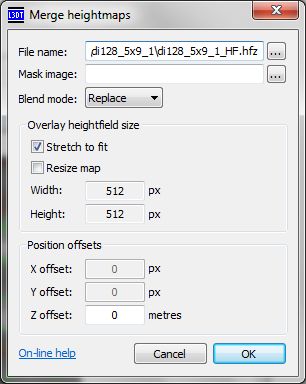 [The updated importer is included in L3DT v2.9 build 8 (31st of Jan), in both Professional and Standard editions. This update also includes some other minor changes, such as support for importing 8-bit mask maps from 24-bit PNG files, and some better event/error logging in ZeoGraph.] The new default settings for the 'Merge heightmaps' window act in the exact same way as the 'BlendHeightfields' graph, but with a few clicks and/or taps of the keyboard you can easily re-configure the merge window to perform other operations (e.g. stitching tiles together, as was the previous default mode for this window). I will update the documentation for this window closer to the release date for L3DT v3.0. In the mean-time, if you have any questions or suggestions about it, please feel free to reply in this thread. Cheers, Aaron.
Re: best of both worlds.. Imported HF but Cool terrain?
Aaron, thanks a ton for this new modification (merge heightfields)!! Worked exactly as I wanted!
This is going to help me immensely (and much more so than my trying to manipulate the BlendHeightfields graph, as I can do more with the Merge Heighfields). You truly made my day. Now off to see what different types of terrain effects I can create with this beauty. Thanks again for all the work you have put into improving L3DT. I can't think of any other software application that I use that the developer(s) has worked so closely with the end-user to improve the product. I will definitely be recommending that other terrain creators in the VBS2/ArmA communities try it out (if they haven't already). Allan Allan Luomala
SkyChasm Consulting - Military Simulation Terrain Specialist http://skychasm-consulting.ca/
Re: best of both worlds.. Imported HF but Cool terrain?
Whoa, nice.
And I'll 2nd Allan there on the complements. As a student, I looked at a lot of terrain apps (free-ware and not) before deciding who to actually spend cash on. I think it was a very good choice.
21 posts
• Page 2 of 2 • 1, 2
Who is onlineUsers browsing this forum: No registered users and 58 guests |

