| L3DT users' wiki |
|
| Large 3D terrain generator |
|
Table of Contents
atMergeMapPlugin information
What does it do?atMergeMap allows you to stitch a second heightmap onto your existing heightmap. Using atMergeMapTo merge a second heightmap with your current heightmap, select the 'File→Import→Merge heightmap' menu option 1). This will open the merge heightmaps window, shown below:

The options are: File nameThe filename of the second imported you wish to merge with the current (original) heightmap. Supported file formats currently include HFZ, HF2, HFF, TER, BT, BMP and PNG, plus MMF for mosaics. Mask imageThe 'mask image' is the filename of an optional overlay mask image that can be used to control the blending between the original heightfield and the imported heightfield. The mask image must be a greyscale image in the PBG or BMP formats. The greyscale values in the mask image are interpreted as follows:
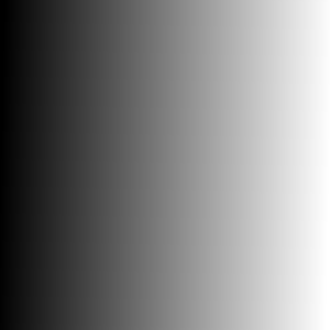
The effect is shown below using a simple mask image that blends from black (100% original heightfield) at the left to white (100% imported heightfield) at the right:
Blend modeThe merge mode drop-list allows you to select the type of blending operation used to combine the imported heightmap with the original heightmap. The supported modes are:
Stretch to fitIf the 'stretch to fit' option is checked, the imported heightfield will be automatically resized to fit exactly over the existing heightfield. If 'stretch to fit' is enabled, the X and Y offset controls are automatically disabled, since to stretch the imported heightfield over the existing heightfield the offset must be zero.
This option is mutually exclusive with the 'resize map' option.
Resize mapIf the 'resize map' option is enabled, you may resize the imported heightmap to cover any arbitrary area of the output heightfield. This option enables the 'width' and 'height' controls, in which you may enter the desired size of the input heightfield, measured in pixels.
This option is mutually exclusive with the 'stretch to fit' option.
Position offsetsX/Y offsetsThe x and y offsets specify the desired positioning of the imported map relative to the original heightfield. The x offset is defined as the distance in the east (right) direction, measured in pixels, that the imported map is offset from the original map. Nagative values imply that the imported map is to the west (left) of the original heightfield. The y offset is defined as the distance in the north (up screen) direction, measured in pixels, that the imported map is offset from the original map. Nagative values imply that the imported map is to the south (below) of the original heightfield. All offsets are measured between the southwest (lower-left) corners of each map, as shown below:
Z offsetThe Z offset allows you to shift the altitude of the imported hightmap relative to the original heightmap. This offset is measured in metres. To-do list
Changes2011/01/31 — Released v2.9.5.0, with blending modes, mask images, and stretch modes. 2009/06/28 — Released v2.7.4.0, with menu option duplicated at 'File→Import→Merge heightmaps', and support for more file formats in file picker window. 2009/01/08 — Released v2.7.0.0, with L3DT release 2.7 beta 1.03. Fixed flag settings for mosaic heightmaps. 2008/12/03 — Released v2.6.1.1, with L3DT release 2.7 beta 1. Added support for 'undo'. 2008/06/09 — Released v2.5.4.0, with L3DT release 2.5.4.3. 2008/02/29 — Released. 1)
Formerly located at 'Extensions→atMergeMap→Merge heightmap'.
Except where otherwise noted, content on this wiki is licensed under the following license:CC Attribution-Share Alike 3.0 Unported
|