|
Table of Contents
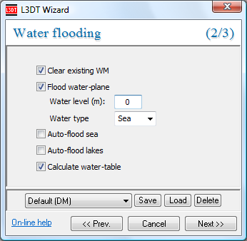
Water map operationsFlooding the water mapTo flood the water map, select the 'Operations→Water map→Flood wizard…' menu option. This wil open the water flooding wizard, shown below: The controls are as follows:
To see a typical water map, go here. Auto-flooding seaL3DT will automatically flood seas wherever the design map has a 'sea seed' special land type. This may be done either by using the auto flood sea option in the water-flooding wizard, or by using the 'Operations→Water map→Auto flood sea' option in the menu.
You can also flood seas manually.
Auto-flooding lakesSimilar to auto-flooding sea, L3DT can automatically flood lakes wherever the design map has a non-zero 'lakes' parameter. This may be done either by using the auto flood lakes option in the water-flooding wizard, or by using the 'Operations→Water map→Auto flood lakes' option in the menu. If you are unhappy with the lakes you may delete individual lakes using the 'delete water body' mouse mode, or clear the whole lot by selecting the 'File→Close→Water map' menu option.
For the 'Auto-flood lakes' option to have any effect, you must set the 'lakes' parameter in the design map parameters wizard to a non-zero number, and/or edit the design map to add non-zero values for the lake field.
You can also flood lakes manually.
Flooding the water-tableThe subterranean water table is required for assigning the land types in the attributes map (see the algorithms page for details). The water table is calculated via the water table modelling wizard, shown below. This window is opened by enabling the calculate water-table option in the water flooding wizard, or by selecting the 'Operations→Water map→Flood water-table' option from the menu. This window exposes the base-level modelling parameters of the water map calculation, which are described - poorly - on the algorithms page. The default parameters were entirely arbitrary (the old 'what looks right' factor), so if you want to change the settings please feel free.
You can change the water map display settings to show or hide the water table, salinity, heightfield contours, etc.
Flooding water manuallyPlease refer to the water flooding tool page. Deleting water bodiesPlease refer to the delete water body tool page. Except where otherwise noted, content on this wiki is licensed under the following license:CC Attribution-Share Alike 3.0 Unported
|


