L3DT users' wiki
Large 3D terrain generator

Map:CreateMosaic filter

Filter info

Description Create and initialise a mosaic map.
Author Aaron
Plugin ZG_map

This filter is equivalent to the Map:CreateMosaic2 filter; the difference being that the filter settings are expressed as options rather than input pins.

Looks like

:plugins:calc:zeograph:filters:map_createmosaic.png

Input pins

This filter has no input pins.

Output pins

Name Type Description
hMap hvar A handle to the map created by this filter.

Options

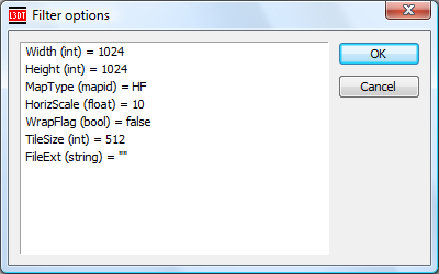
The filter options window for CreateMosaic looks like:

:plugins:calc:zeograph:filters:map_createmosaic_options.png

The options are as follows:

Option name Data type Description
Width int The desired width of the map (east-west), in pixels.
Height int The desired height of the map (south-north), in pixels.
MapType mapid The desired map type (double-click to select from list).
HorizScale float The desired horizontal spacing between map pixels, in metres.
WrapFlag bool A flag for whether the map's north/south and east/west borders should tile seamlessly with one another.
TileSize int The side-length of each tile in the mosaic map, in pixels.
FileExt string The file extension of the file format to be used for the tile files (e.g. “HFZ”, “JPG”.)

To edit any of the values, double left-click the mouse on them.

Comments

None.

 
plugins/calc/zeograph/filters/map_createmosaic.txt · Last modified: 2017/08/31 04:27 (external edit)
 
Except where otherwise noted, content on this wiki is licensed under the following license:CC Attribution-Share Alike 3.0 Unported
Recent changes RSS feed Donate Powered by PHP Valid XHTML 1.0 Valid CSS Driven by DokuWiki